In pics: Historic photos taken by US bombers show changing face of Switzerland
The Swiss government has just published a remarkable archive of historical photos taken from the air which reveal how much the country has changed in the last 70 years.
The photos of Switzerland were captured by US bomber pilots in 1946 as part of Operation Casey Jones – a joint US–UK operation to create an aerial map of post-war Europe.
A total of around 4,200 high-quality images were captured during 64 flights from May to September that year after Swiss authorities gave the go-ahead for the flights on the condition that Swiss observers be allowed on board.
The photos have been digitally restored and are now available online at the Swiss Federal Office of Topography website. A clever mapping tool also allows users to compare the unique historical images of what was still a largely agricultural Switzerland with the country of today.
To see the transformation, drag the arrow tool left or right across the screen in the images below:
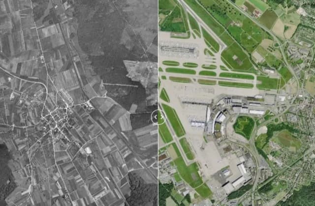
Zurich's Kloten airport in 1946 and today
Airolo in the canton of Ticino
The Rhine Port in Birsfelden in the canton of Basel–Landschaft
The man made Lac de la Gruyère in canton Fribourg.
Morges in the canton of Vaud
Sion/Sitten in the canton of Valais
Schlieren in the canton of Zurich
Read also: QUIZ: How well do you know these key dates in Swiss history?
Comments
See Also
The photos of Switzerland were captured by US bomber pilots in 1946 as part of Operation Casey Jones – a joint US–UK operation to create an aerial map of post-war Europe.
A total of around 4,200 high-quality images were captured during 64 flights from May to September that year after Swiss authorities gave the go-ahead for the flights on the condition that Swiss observers be allowed on board.
The photos have been digitally restored and are now available online at the Swiss Federal Office of Topography website. A clever mapping tool also allows users to compare the unique historical images of what was still a largely agricultural Switzerland with the country of today.
To see the transformation, drag the arrow tool left or right across the screen in the images below:
Zurich's Kloten airport in 1946 and today
Airolo in the canton of Ticino
The Rhine Port in Birsfelden in the canton of Basel–Landschaft
The man made Lac de la Gruyère in canton Fribourg.
Morges in the canton of Vaud
Sion/Sitten in the canton of Valais
Schlieren in the canton of Zurich
Read also: QUIZ: How well do you know these key dates in Swiss history?
Join the conversation in our comments section below. Share your own views and experience and if you have a question or suggestion for our journalists then email us at [email protected].
Please keep comments civil, constructive and on topic – and make sure to read our terms of use before getting involved.
Please log in here to leave a comment.