'Intense continuous rain': Switzerland extends heavy weather forecast until end of week
Many Swiss regions are still impacted by rains and winds, with more of the same expected until the end of the week.
The Federal Office of Meteorology (MeteoSchweiz) is reporting “intense continuous rain” over much of the country.
Warnung des Bundes: intensiver Dauerregen. Gefahrenstufe 2 und 3 (von 5). Betroffene Regionen, weitere Informationen und Verhaltensempfehlungen auf https://t.co/fR0rVJKQQO und https://t.co/EVnQ0ywRjT oder auf der MeteoSwissApp. #MeteoSchweiz pic.twitter.com/y3g8sY8Eke
— MeteoSchweiz (@meteoschweiz) July 14, 2021
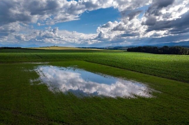
Flooding remains a major threat, as lakes and rivers are overflowing in some regions.
This is the situation in parts of the country right now
A Danger Notice 3, which means “marked danger”, has been issued for Lake Geneva, as its present level “is worrying”, according to Etienne Monbaron, hydrologist at the city’s Water Ecology Service.
The lake will continue to rise slowly throughout Thursday and Friday, reaching “levels not seen for decades”, Monbaron predicted.
Cantons of Geneva and Vaud are affected, along with towns on the French side of the lake.
In central Switzerland, Lake Luzern and Lake Thun have exceeded the flood threshold during the night from Tuesday to Wednesday, while Lake Biel / Bienne is at the limit.
Aufgrund der aktuellen Wetterlage ist davon auszugehen, dass der Pegelstand des Bielersees weiter ansteigen wird, was zu Überschwemmungen führen wird.
📞Info-Hotline für die Bevölkerung: 032 326 22 53.#Unwetter #Hochwassergefahrhttps://t.co/9wcWXq9Snp
— Biel/Bienne (@BielBienne_off) July 13, 2021
The Zurich waters were all just below alert level 4 on Wednesday morning, a few centimetres below the high water mark. However, the canton expects that this mark will be exceeded in the next few days.
The level of the Limmat river is also likely to rise further due to the high level of Lake Zurich. As a precautionary measure, the Sihlsee dam was lowered on Tuesday evening so as not to put additional strain on the Limmat.
In Basel, the water level on the Rhine is too high, paralysing shipping traffic on the river in Switzerland’s only international port.
How long is this situation expected to last?
More rain is forecast for Thursday, causing further flooding.
This weather is likely to continue until Saturday, with water accumulation reaching up to 150 litres per square metre, further filling up rivers and lakes in some regions.
Alert level 4 out of 5 is not excluded for this weekend, according to MeteoSchweiz.
What can you do to keep safe?
Authorities advise against walking or standing on the banks of lakes and rivers.
If you live in close proximity to waterways, you should remove vehicles from underground garages.
And you should also stay continually informed about the situation in your area with the AlertSwiss App.
READ MORE: Thunderstorms and wild weather to continue across Switzerland until Thursday
Comments
See Also
The Federal Office of Meteorology (MeteoSchweiz) is reporting “intense continuous rain” over much of the country.
Warnung des Bundes: intensiver Dauerregen. Gefahrenstufe 2 und 3 (von 5). Betroffene Regionen, weitere Informationen und Verhaltensempfehlungen auf https://t.co/fR0rVJKQQO und https://t.co/EVnQ0ywRjT oder auf der MeteoSwissApp. #MeteoSchweiz pic.twitter.com/y3g8sY8Eke
— MeteoSchweiz (@meteoschweiz) July 14, 2021
Flooding remains a major threat, as lakes and rivers are overflowing in some regions.
This is the situation in parts of the country right now
A Danger Notice 3, which means “marked danger”, has been issued for Lake Geneva, as its present level “is worrying”, according to Etienne Monbaron, hydrologist at the city’s Water Ecology Service.
The lake will continue to rise slowly throughout Thursday and Friday, reaching “levels not seen for decades”, Monbaron predicted.
Cantons of Geneva and Vaud are affected, along with towns on the French side of the lake.
In central Switzerland, Lake Luzern and Lake Thun have exceeded the flood threshold during the night from Tuesday to Wednesday, while Lake Biel / Bienne is at the limit.
Aufgrund der aktuellen Wetterlage ist davon auszugehen, dass der Pegelstand des Bielersees weiter ansteigen wird, was zu Überschwemmungen führen wird.
— Biel/Bienne (@BielBienne_off) July 13, 2021
📞Info-Hotline für die Bevölkerung: 032 326 22 53.#Unwetter #Hochwassergefahrhttps://t.co/9wcWXq9Snp
The Zurich waters were all just below alert level 4 on Wednesday morning, a few centimetres below the high water mark. However, the canton expects that this mark will be exceeded in the next few days.
The level of the Limmat river is also likely to rise further due to the high level of Lake Zurich. As a precautionary measure, the Sihlsee dam was lowered on Tuesday evening so as not to put additional strain on the Limmat.
In Basel, the water level on the Rhine is too high, paralysing shipping traffic on the river in Switzerland’s only international port.
How long is this situation expected to last?
More rain is forecast for Thursday, causing further flooding.
This weather is likely to continue until Saturday, with water accumulation reaching up to 150 litres per square metre, further filling up rivers and lakes in some regions.
Alert level 4 out of 5 is not excluded for this weekend, according to MeteoSchweiz.
What can you do to keep safe?
Authorities advise against walking or standing on the banks of lakes and rivers.
If you live in close proximity to waterways, you should remove vehicles from underground garages.
And you should also stay continually informed about the situation in your area with the AlertSwiss App.
READ MORE: Thunderstorms and wild weather to continue across Switzerland until Thursday
Join the conversation in our comments section below. Share your own views and experience and if you have a question or suggestion for our journalists then email us at [email protected].
Please keep comments civil, constructive and on topic – and make sure to read our terms of use before getting involved.
Please log in here to leave a comment.