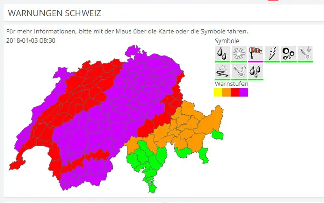
Winds of 90-130km/hr are expected across the Swiss plains during the morning, at their peak from 10am to midday, with gusts of up to 150km/hr predicted at higher elevation, MeteoNews said.
In most places the storm will bring heavy rain or even hail, though the southern canton of Valais should expect snow above 1,600m throughout Wednesday.
Drivers should expect difficult conditions on the roads with limited visibility due to swirling spray and a risk of aquaplaning, said meteorologists.
02.01.2018 - #Burglind ist im An#sturm, beachtet unbedingt die #Wetterwarnungen. Im Notfall 117 wählen, wir sind für euch da.https://t.co/2bCUoiJh5w pic.twitter.com/Yp4eyI4Dqe
— Kantonspolizei St.Gallen (@kapoSG) January 2, 2018
In Vaud, Swiss federal railways (SBB) said the mountain railway line from Haut-de-Caux to Rochers-de-Naye would remain shut throughout the day due to strong winds, with no replacement service.
Another mountain railway in the canton of St Gallen, between Weissbad and Wasserauen, was also shut for the same reason, as were cable cars around the country.
Kanton Zürich: Sturmwarnung, Hinweise zur Gefahrenabwehr
— Kantonspolizei Zürich (@KapoZuerich) January 2, 2018
Gemäss aktuellem Bulletin der MeteoSchweiz ist für Mittwoch, 3. Januar 2018, zwischen 03:00 Uhr und 21:00 Uhr im ganzen Kanton Zürich mit sehr heftigen, zum Teil orkanartigen, Sturmböen zu rechnen.https://t.co/plxNjmDAIZ pic.twitter.com/8wmOUsPdnr
Some police forces issued warnings, advising people to take care when out and about, and avoid walking in wooded areas due to the risk of falling trees.
The wind should lessen slightly in the afternoon.
Comments