Currently, there are over 200 at risk-areas under observation in Switzerland's Alpine cantons, according to new data.
Higher temperatures are causing glaciers to melt and permafrost to thaw, making mountains increasingly unstable.
"Gravitational mass movements have always been a significant threat to people, settlements, transport, and other infrastructure in Switzerland. Such processes can occur throughout the mountainous region," Daniela Mangiarratti of the Federal Office for the Environment (FOEN) told 20 Minuten.
However, these movements are expected to become more frequent in Switzerland in the future as a result of global warming, she said.
In the cantons of Bern and Graubünden alone, almost 200 landslide-prone mountain slopes are currently under observation – sometimes around the clock.
The data for Bern and Graubünden includes all monitoring activities related to so-called gravitational processes. These refer to rockfalls, landslides, and mudslides.
READ ALSO: How Switzerland's Birch glacier collapsed
When the risk of such events is classified as high – ie there is a danger of injury or death, or the destruction of homes and infrastructure – a variety of measuring methods are used as part of the monitoring process, from instruments to detect emerging cracks or movements downstream to the installation of cameras, GPS sensors, and satellites.
But it can be difficult to get a comprehensive overview of the potential risk level as Switzerland does not produce a nationwide map – the individual cantons each publish their own data with different levels of detail.
"The FOEN does not have a national overview that shows where there is an increased risk of rockslides, avalanches, or landslides," Mangiarratti said, explaining that various factors played a role in hazard exposure.
"In addition, hazards often change over the years, sometimes within a few months," she added.
The available cantonal data shows that the three most at-risk areas can, perhaps unsurprisingly, be found in Switzerland's three highest Alpine cantons.
Bern
Bern has 155 risk locations on the monitoring systems' inventory list, according to cantonal data.
The most well-known example is the Spitze Stein, a standing stone above Lake Oeschinen in Kandersteg in the Bernese Oberland. It's monitored 24 hours a day.
It's been designated a landslide area because experts say there are 16 million cubic metres of unstable rock and debris on the mountain. That's more than fell from the mountain in Blatten.
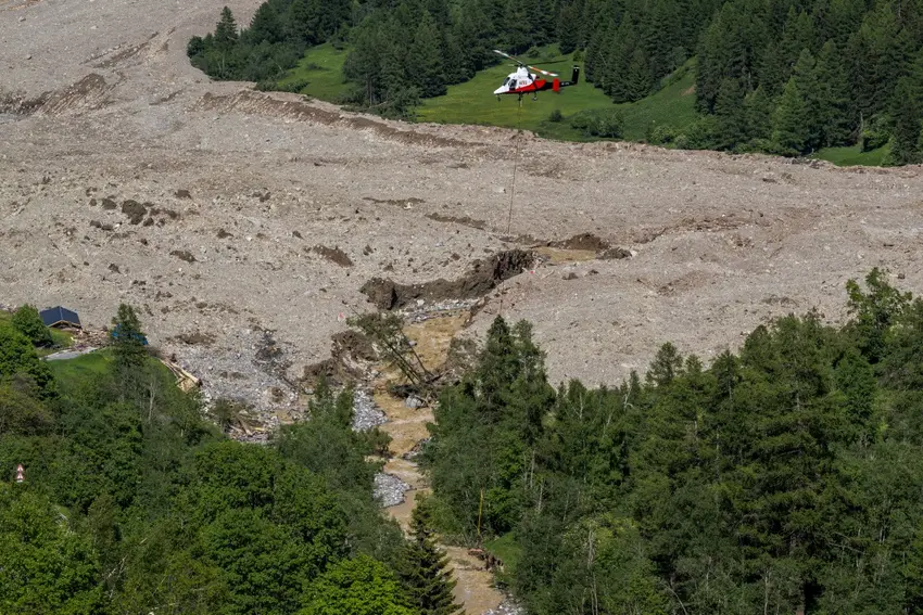
READ ALSO: Images reveal how Swiss village was destroyed and flooded in glacier collapse
Other mountainous areas in the canton are also monitored, such as rock faces and ski slopes, the Schilthorn summit, the Adelboden Alpine village, as well as areas above exposed roads, like along Lake Brienz, or the Niesenbahn viaduct.
Graubünden
Graubünden cantonal data shows that there are 42 at-risk locations being monitored by state or canton-subsidised systems.
Areas monitored by municipalities or mountain railway operators are not included here.
The best-known at-risk area being monitored in Graubünden is Brienz, which is located at the foot of a massive Alpine rock. Residents were safely evacuated in 2023 due to a huge impending landslide that had threatened to bury the village but in the end stopped just short.
They have not been allowed to stay overnight in the village since November 2024 due to the ongoing risk.
On Monday, the village was again completely closed off to residents due to the increased threat of a potential landslide.
Areas near Arosa are also being monitored for landslides while mountain movements are being measured at the Charnadüra tunnel near St Moritz.
Valais (Wallis)
The current number of unstable rock faces in the canton of Valais is unclear as the cantonal data has not been updated since 2018. At that time, the canton published a list of 70 areas, which were being monitored for potential mudslides, landslides, and rockfalls.
Meanwhile, a 2021 study on the canton (part of the national pilot programme for climate change adaptation) showed that there were 89 "potentially unstable and critical" rockfaces in the canton.
Most of these were in the canton's southern valleys, such as Val d’Hérens, Val d’Anniviers, Val de Bagnes, Mattertal and Saastal.
Whilst the data itself does not mention monitoring, it's safe to assume that these areas are being/will be monitored.
The investigations into the affected rock faces were not yet complete, Raphaël Mayoraz, head of the Natural Hazards Department, told Berner Zeitung, explaining that they were now examining the measures – such as monitoring – to be taken.
Comments